
Trail Beer Refinery
With a name that reflects Trail’s historic connection to mining, refining, and smelting, this brewery has a strong community focus. For the 13 local business partners who joined together to open Trail’s first craft brewery, it was an obvious choice to link its name to the city’s main industry. Trail
Cranbrook
Welcome to Cranbrook! There is so much amazing riding here to be had, both on and off-road. Here’s a selection of things you can ride,
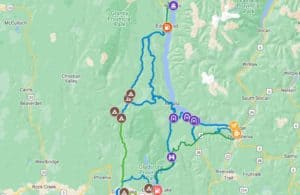
Kootenay Rockies North
There sure is a heck of a lot to explore in the Kootenay Rockies North area! Sooooo many jagged peaks and mountain streams…. Get the
Kimberly
Welcome to Kimberly! A little bit of Bavaria tucked into the mountains of BC. There is so much amazing riding here to be had, both
Bulldogish
What’s Bulldogish? Well, for lack of a better name, it’s the network of roads and trails that wander around the Bulldog Tunnel. Encompassing a loose
Rocky Mtn Network
What’s the Rocky Mtn Network? Well, its the corridor of awesomeness that runs North/South along and near the Canadian Rockies. And boy is it a
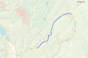
Kid Creek / Moyie River FSR
A gravel shortcut from Kitchener to the North end of Moyie Lake! The Route follows the Kid Creek and Moyie River FSRs and cuts off